Mt. Blue Ski Area
Benton & Woodstock, New Hampshire
Proposed in the 1930s
 Overview
A subpeak of Mt. Moosilauke, Mt. Blue was a proposed location of the aerial tramway eventually installed at Cannon Mountain.
Alexander Bright produced a report on the proposed area, while American Steel & Wire conducted a study on a lift.
The base area would have been located along the present day Route 112. Though Moosilauke offered above treeline skiing, Cannon was chosen due to the better topography for a lift line, the proximity to scenery such as Old Man of the Mountain, and access to infrastructure (such as electricity).
Decades later, Mt. Blue emerged as a potential alpine skiing venue for a 1976 Winter Olympics bid.
Another ski area was proposed nearby, called Waternomee Glen.
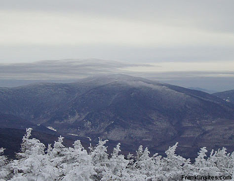
Mt. Blue as seen from South Kinsman (2009)
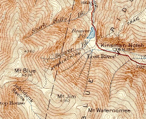
1932 USGS Topographic Map of Mt. Blue
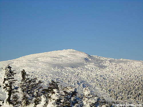
The Mt. Moosilauke snowfields (2010)
Today
There are no known remains of the Mt. Blue Ski Area.
Quotes
| " |
1934: Mt. Blue is one of two sites (along with Cannon Mtn.) considered for construction of aerial tramway for skiers. Cost estimate for Mt. Blue location by American Steel & Wire Co. is $180,000 tramway with vertical descent of 2470 ft. On map of proposal, valley station is shown at S end of Beaver Pond and mountain station on summit of Mt. Blue, with cable passing over Beaver Brook Trail and cascades.
|
" |
|
The 4000-Footers of the White Mountains: A Guide and History, p. 432
| |
| " |
Between the wars, some aerial tramways were built for passengers in Europe, and several American skiers were aware of them and championed the concept in the US. Foremost among these was Alec Bright of Boston, a founder of the Ski Club Hochgebirge. In 1934 Bright conducted a survey of potential sites for tramways in the White Mountains, and noted that American Steel & Wire had already developed cost estimates for tramways at two locations in New Hampshire, at Cannon Mountain and Mt. Moosilauke. Through the activism of Bright and Roland Peabody, the State of New Hampshire financed an aerial tramway at Cannon, which opened in 1938. While this was the first tramway built in the U.S. intended to carry skiers as well as summer sightseers, it was not the first passenger tramway in the country.
|
" |
|
Jeff Leich, "Smoothing the Way For Today�s Skiers"
| |
| " |
Two sites, Cannon Mountain and Mt. Blue, were considered likely enough that serious cost estimates were done; based on these, the costs of the other sites were estimated at $200,000 per mile of cable length. Topography would modify these rough estimates in that steep, concave slopes were the cheapest because linear distance and towers were minimized.
Mt. Moosilauke was well-known to skiers at the time due to its ownership by Dartmouth College, whose Outing Club had been instrumental in the popularization of skiing. The Carriage Road on Moosilauke had been the site of the first downhill race in the country in 1927. One of the big attractions of running a tramway to the Mt. Blue summit would be the open snowfields at Moosilauke's summit, swept by bitter winds in winter storms but able to provide acres of skiing in spring conditions.
Released in July, 1934, Alexander Bright's report on the Moosilauke location read in full:
"Cost carefully estimated by the American Steel & Wire Company totals $ 180,000.00, on an East Northwest location. Vertical descent 2470 ft. Snow cover at the summit, 4810 ft. is estimated at 270", and 160" at the base. The Tramway's top station would be 8/10 of a mile from the summit of Mt. Moosilauke, necessitating a descent of 200 ft. then a climb of 500 ft. to reach the summit of Mt. Moosilauke. The area amply supplies every winter requirement, although the summit of Mt. Moosilauke is above treeline and considerable (sic) windswept. There is not much variety of Summer climbing activities for hikers.
Good contour of slope is a factor to consider for selecting an effective location for a Tramway. Traffic is average on the Lost River Road according to the New Hampshire Foundation which estimates 1600 persons per day for the period from July 17 to October 16, 1931. It is relatively not dense as compared to many main arteries. The proposed site is not too well concealed from the highway." In contrast, the cost estimate for the Cannon Mt. project was $ 152,000.00 for a vertical drop of 1820 feet and skiing on north and eastern exposures. Unlike the Mt. Blue site, sufficient electric power was already in place in Franconia Notch."
A map accompanying a 1935 report from the American Steel & Wire Company shows the valley station of the Moosilauke tram located at the southern end of Beaver Pond in Kinsman Notch, with the mountain station on the summit of Mt. Blue. With this alignment the cable would pass almost directly over the cascades of Beaver Brook and the Beaver Brook Trail, then as now a segment of the Appalachian Trail.
|
" |
|
Jeff Leich, "The Mount Moosilauke Aerial Tramway Proposal"
| |
| " |
Two of the acceptable complexes were in New Hampshire, one the Mt. Washington Valley region in the eastern slope area of the White Mountain National Forest, the other the White Mountain 93 area, including Cannon Mountain, Mt. Blue, Mt. Bond, and North Twin Mountain.
|
" |
|
Mike Beatrice, 1967
| |
Resources
Beatrice, Mike. "Maine Site Seeks '76 Olympics." Boston Globe. 24 Jan. 1967.
Leich, Jeff. "The Mount Moosilauke Aerial Tramway Proposal." New England Ski Museum Newsletter. Winter 1998. http://www.mtmoosilauke.com/aerialtram.html.
Leich, Jeff. "Smoothing the Way For Today�s Skiers." New England Ski Museum Online Journal. July 14, 2007. http://www.skimuseum.org/page.php?cid=doc122.
Smith, Steven D. and Mike Dickerman. The 4000-Footers of the White Mountains: A Guide and History. Second edition. Littleton, NH: Bondcliff Books, 2008.
Waternomee Glen Ski Area - New England's Cancelled Ski Areas
Last updated: March 19, 2013
|
|
