Connecticut
Maine
Massachusetts
New Hampshire
Rhode Island
Vermont
Want to advertise on NewEnglandSkiHistory.com?
Jay Peak Images
Return to Jay Peak Profile
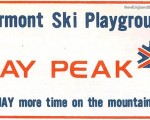
Jay Peak Vintage Ads
Jay Peak
1959-60 Eastern Ski Map
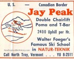
Jay Peak
1960-61 Eastern Ski Map
Jay Peak
1970 Granby Leader Mail
Jay Peak
1970-71 Eastern Ski Map
Jay Peak
1971-72 Eastern Ski Map
Jay Peak
1972-73 Eastern Ski Map
Jay Peak
1973-74 Eastern Ski Map
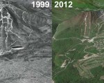
Jay Peak Then and Now
Jay Peak
Jay Peak Aerial Imagery, 1999 vs. 2012
See also: Lifts and Maps at
Jay Peak Profile
Advertisement
Topics
Links
What's New
Feedback
Copyright 2002-2024, All Rights Reserved.